PIX4D PIX4DCloud
PIX4D Item #:PIX4DCloud
Please call us at +1-800-322-5003 or click below to request a price quote.
Pix4Dcloud
The online platform for drone mapping, progress tracking, and site documentation
Capture
Collect site images using drones, handheld cameras or the Pix4D Crane Camera.
Process
Automatically process your images on the cloud using photogrammetry algorithms to transform them into measurable deliverables. Generate accurate and georeferenced orthomosaics, 3D meshes, point clouds, and elevation models.
Analyze
Visualize, monitor and document site progress using an intuitive interface, a timeline, and built-in measurement tools, accessible online from any device or location, on a collaborative cloud-based platform.
Share
With a simple URL, share the results with your team or clients to ensure seamless information flow and greater collaboration.
Integrate
Download all outputs and export to third-party CAD and BIM software for further steps.
Professional photogrammetry on the cloud
Accurate results
Rely on Pix4D’s processing algorithms to get the survey-grade results you expect. Choose the AutoGCPs feature for even greater accuracy.
Analysis made easy
Get an instant view of any jobsite from anywhere, on your browser, in 2D and 3D, with results you can measure, explore, compare, share and collaborate on.
Up-to-date documentation
Keep a permanent and up-to-date record of the project and resolve disputes efficiently.
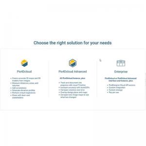
Map, measure, and document the progress of your site
- Improve accuracy
- Boost your project accuracy with the AutoGCPs feature, automatically marking GCPs without manual intervention
- Timeline analysis
- Visual timeline of your jobsite for site tracking and project documentation
- Calculate and compare volumes
- Perform quick and precise volume calculations and compare them over time
- Overlay design plans and maps
- Compare the as-built with the as-designed instantly to verify site progress
- Compare image maps over time
- Compare two specific days to spot what has changed
- Virtual inspections
- Remotely inspect any jobsite from any device or location, just with an internet connection
- Measure, annotate and share
- Measure distances, highlight critical elements and share data with your team, clients or stakeholders
